Welcome to Machu Picchu travel guide.
Machu Picchu
|
 The Citadel of Machu Picchu is as we know today this fortress from the Inca Empire whose ruins date from the 1300 DC. The Citadel contains the remains of the ancient settlement formed by this village part of the Inca civilization, located at the east side of the valley constituted by mountain systems, Machu Picchu and Huayna Picchu, and the Central Andes in the South of the country. The Citadel of Machu Picchu is as we know today this fortress from the Inca Empire whose ruins date from the 1300 DC. The Citadel contains the remains of the ancient settlement formed by this village part of the Inca civilization, located at the east side of the valley constituted by mountain systems, Machu Picchu and Huayna Picchu, and the Central Andes in the South of the country.
|
|
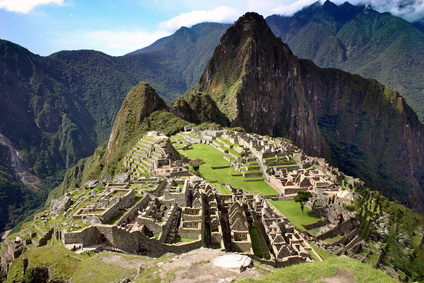 The Inca Empire was able to perform the most extraordinary architecture works that still can be appreciated from the large number of ruins left, all over the mountain system that surrounds the Citadel of Machu Picchu. Indescribable designs and great architectural organization were the main facts to make possible such an incredible city that was dividedin a number of sections. The Inca Empire was able to perform the most extraordinary architecture works that still can be appreciated from the large number of ruins left, all over the mountain system that surrounds the Citadel of Machu Picchu. Indescribable designs and great architectural organization were the main facts to make possible such an incredible city that was dividedin a number of sections.
|